Tyrol, the third largest state in Austria with 12,640 km 2 and with a population of (2018) 751 200, the most sparsely populated (59 residents per km 2).
Tyrol is made up of the spatially separated parts of North Tyrol (between Bavaria in the north, Salzburg in the east, Switzerland and Italy in the south and Vorarlberg in the west) and East Tyrol (borders Salzburg in the north and Carinthia in the east) (as a result of the separation of South Tyrol) and in the south and west to Italy) together; The capital is Innsbruck. Tyrol is divided into eight political districts, which together comprise 279 municipalities (including 11 municipalities and 21 market municipalities), and one city with its own statute (Innsbruck).
Geography
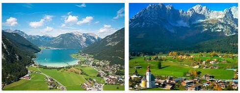
Both parts of Tyrol are distinct high mountain areas. North Tyrol includes part of the Northern Limestone Alps (Allgäu Alps, Lechtal Alps, Tyrolean-Bavarian Limestone Alps, Loferer and Leoganger Steinberge), mostly rugged chain mountains, between which transitions, v. a. over the Fernpass, the Seefelder Sattel, the furrow of the Achensee (Achenpass) and the Innquertal below Kufstein, from the Inn Valley to the Bavarian Alpine foothills.
South of the Stanzer Tal (from the Arlberg), the Innlängstal (between Landeck and Wörgl) and the saddle of Ellmau, groups of the central Alps and the northern Grauwackenzone mainly consist of crystalline rocks belong to Tyrol: the Verwall group, parts of the Silvretta and Samnaun group as well as the main watershed of the Ötztaler, Stubai and Zillertal Alps; they rise to well over 3,000 m above sea level, are heavily glaciated and divided by long, deeply sunk transverse valleys (Inntal above Landeck, Kauner, Pitz, Ötz, Stubai, Wipp, Zillertal). The Gepatschferner is the largest glacier in Tyrol and the second largest in Austria. Between the Central and Northern Limestone Alps, east of Schwaz, the Grauwacken or slate zone (Kitzbühel Alps) intervenes with gentler forms.
East Tyrol is located on the south side of the Central Alps (south or south-west part of the Venediger and Glockner groups of the Hohe Tauern, Defereggen Mountains, Schober group) and is drained to the Lienz basin through the pinnately branched valley system of the Isel. The extreme south is formed by the limestone mountains of the Lienz Dolomites (Gailtal Alps) south of the Drava and the northern roof of the westernmost part of the Carnic Alps.
Climate: Tyrol has a moderate mountain climate, which is, however, heavily modified by the differences in relief. The summit areas receive heavy precipitation (up to 2,000 mm annually; in East Tyrol, abundant accumulated precipitation when warm and humid air masses are supplied from the south); the upper Inn valley and the valleys of East Tyrol are relatively low in precipitation with 800 to 1,000 mm annually. In the narrow high mountain valleys, the duration of sunshine is very different, so in Paznaun (western Tyrol) the shady side receives only about half the amount of heat that the sunny side receives during a year.
Protected by mountain ranges at the edge, the upper, but also the middle Inn valley enjoys a relatively long annual sunshine. The hair dryer plays a not insignificant role here. Innsbruck (574 m) with an average annual precipitation of 888 mm and an average annual temperature of 9.4 ° C differs from Kufstein (499 m), where the corresponding values are 1,332 mm and 8.6 ° C. The central area of East Tyrol, the Lienz Basin, is also characterized by the protection of high mountain ranges through long hours of sunshine and low rainfall (for Lienz 900 mm / year). In the sequence of vegetation levels – even in the climatically mild Innsbruck area – the colline level (vegetation levels) is only rudimentary.
Population
Since records began in 1896 (today’s territorial status) in Tyrol, the birth and migration balance have generally shown a positive balance. The birth balance rate was 2.4 ‰ in 2016, the migration balance rate 7.0 ‰ (national average: 0.8 ‰ and 7.4 ‰). In a comparison of the federal states, the proportion of permanent settlement areas in the land area in Tyrol is the lowest at 12.4% (national average: 38.9%). The main settlement area is the Inntal (Inn) with sometimes well over 100 residents per km 2, followed by the valleys of Lech, Isel and Drau as well as their side valleys. The clear majority of the residents live between 400 and 800 m above sea level. The highest permanent rural settlement (2,014 m above sea level) is the Rofenhöfe near Sölden (Ötztal). The predominant form of settlement are clustered villages on alluvial cones.
Religion: The last census to collect data on religious affiliation was in 2001. At that time over 83% of the population were Catholic and around 2.4% Protestant. Since then, only the number of members of individual religious communities can be used as a basis. The diocese of Innsbruck is responsible for the majority of Catholic Christians in Tyrol; those who live in the area east of Inn and Ziller belong to the Archdiocese of Salzburg. The number of members of the Catholic Church fell in both structural units (in the Diocese of Innsbruck to a total of 388 552, in the Archdiocese of Salzburg to a total of 473 022 [as of 2015]). The evangelical Christians belong to Evangelical Church of the Augsburg and Helvetic Confessions in Austria. Responsible for the Lutherans (A. B.) and Reformed (H. B.) living in Tyrol are the supreme superintendencies (dioceses) Salzburg and Tyrol or Carinthia and East Tyrol. The number of Muslims living in Tyrol was just under 42,000 in 2012 (source: statista). There is a Jewish community in Innsbruck (Israelitische Kultusgemeinde für Tirol and Vorarlberg).